I am a postdoctoral researcher at the Institute of Remote Sensing and Geographic Information System at Peking University. My research asks how multimodal models can help us understand cities. I work across street-level panoramas and satellite imagery, and increasingly with the language people use to describe places, building models that reason across these views instead of treating them separately. I am drawn to multimodal large language models and agentic systems for geospatial intelligence — models that perceive cities more sharply, understand them more deeply, and hold up at scale across thousands of them.
At Peking University I work with Fan Zhang and Yu Liu. Before that, I completed my PhD at the Hong Kong University of Science and Technology, advised by Fan Zhang and Mengqian Lu. I received my MPhil at LIESMARS, Wuhan University, supervised by Zhenfeng Shao.
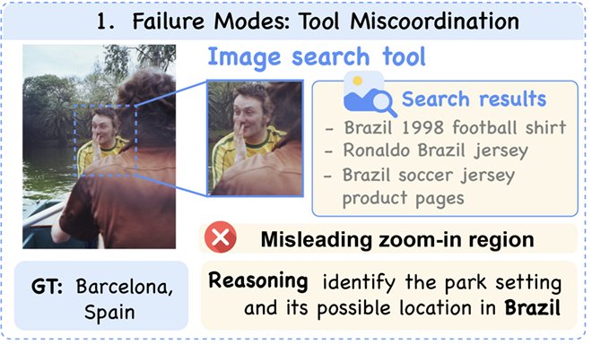
Our paper REVERSE, an agentic framework that reinforces evidence verification and search for image geo-localization, is accepted to NeurIPS 2026.
Apr 20, 2026
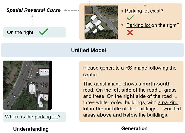
Our paper Uni-RS, a spatially faithful unified understanding and generation model for remote sensing, is accepted to IJCAI 2026.
Feb 26, 2026
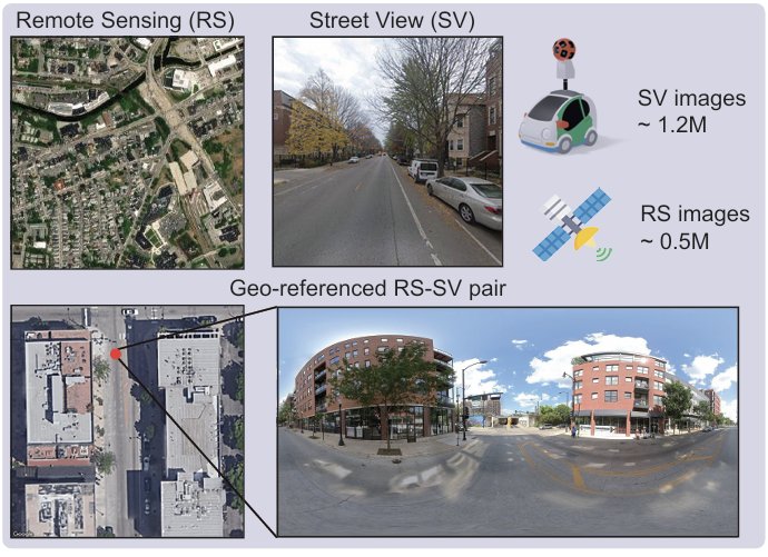
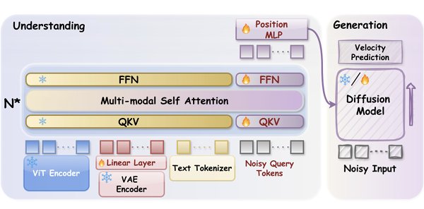
Our paper Unified Urban Tuning, a progressive tuning framework that co-enhances satellite and street view reasoning, and WeMMU, which bridges vision-language models and diffusion models through noisy query tokens, are accepted to CVPR 2026.
selected publications
REVERSE: Reinforcing Evidence Verification and Search for Agentic Image geo-localization
Yong Li, Furong Jia, Dacheng Yin, Kang Rong, and 3 more authors
In Advances in Neural Information Processing Systems, 2026
@inproceedings{li2026reverse,title={REVERSE: Reinforcing Evidence Verification and Search for Agentic Image geo-localization},author={Li, Yong and Jia, Furong and Yin, Dacheng and Rong, Kang and Rao, Fengyun and Lyu, Jing and Zhang, Fan},booktitle={Advances in Neural Information Processing Systems},year={2026},}
Uni-RS: A Spatially Faithful Unified Understanding and Generation Model for Remote Sensing
Weiyu Zhang, Yuan Hu, Yong Li, and Yu Liu
In Proceedings of the Thirty-Fifth International Joint Conference on Artificial Intelligence, 2026
@inproceedings{zhang2026uni,title={Uni-RS: A Spatially Faithful Unified Understanding and Generation Model for Remote Sensing},author={Zhang, Weiyu and Hu, Yuan and Li, Yong and Liu, Yu},booktitle={Proceedings of the Thirty-Fifth International Joint Conference on Artificial Intelligence},year={2026},}
Unified Urban Tuning: Co-Enhancing Satellite and Street View Reasoning with a Progressive Tuning Framework
Yong Li, Weiyu Zhang, Ling Dai, Jian Yang, and 5 more authors
In Proceedings of the IEEE/CVF Conference on Computer Vision and Pattern Recognition Findings, 2026
@inproceedings{li2026unified,title={Unified Urban Tuning: Co-Enhancing Satellite and Street View Reasoning with a Progressive Tuning Framework},author={Li, Yong and Zhang, Weiyu and Dai, Ling and Yang, Jian and Yin, Dacheng and Li, Sirun and Lyu, Jing and Rao, Fengyun and Zhang, Fan},booktitle={Proceedings of the IEEE/CVF Conference on Computer Vision and Pattern Recognition Findings},pages={6302--6311},year={2026},}
WeMMU: Enhanced Bridging of Vision-Language Models and Diffusion Models via Noisy Query Tokens
Jian Yang, Dacheng Yin, Xiaoxuan He, Yong Li, and 5 more authors
In Proceedings of the IEEE/CVF Conference on Computer Vision and Pattern Recognition, 2026
@inproceedings{yang2026wemmu,title={WeMMU: Enhanced Bridging of Vision-Language Models and Diffusion Models via Noisy Query Tokens},author={Yang, Jian and Yin, Dacheng and He, Xiaoxuan and Li, Yong and Rao, Fengyun and Lyu, Jing and Zhai, Wei and Cao, Yang and Zha, Zheng-Jun},booktitle={Proceedings of the IEEE/CVF Conference on Computer Vision and Pattern Recognition},pages={17609--17618},year={2026},}
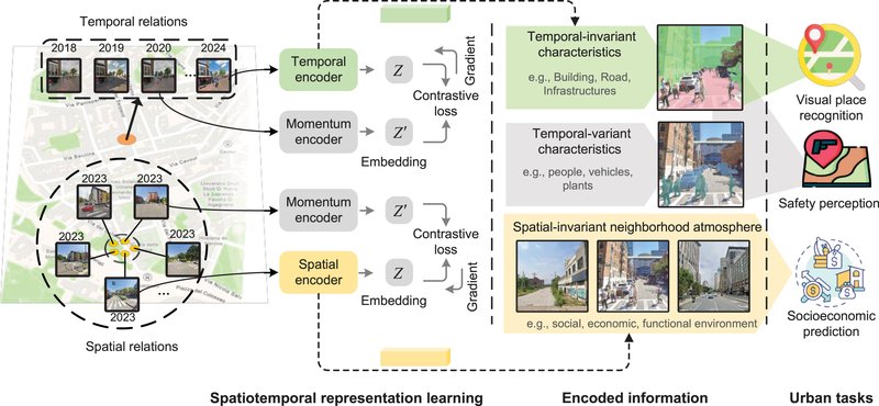
Learning street view representations based on a spatiotemporal contrastive learning framework
@article{li2026learning,title={Learning street view representations based on a spatiotemporal contrastive learning framework},author={Li, Yong and Huang, Yingjing and Zhang, Fan},journal={Computers, Environment and Urban Systems},volume={125},pages={102393},year={2026},publisher={Elsevier},doi={10.1016/j.compenvurbsys.2025.102393},}
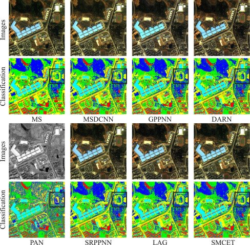
Pan-sharpening via Symmetric Multi-Scale Correction-Enhancement Transformers
Yong Li, Yi Wang, Shuai Shi, Jiaming Wang, and 3 more authors
@article{li2025pan,title={Pan-sharpening via Symmetric Multi-Scale Correction-Enhancement Transformers},author={Li, Yong and Wang, Yi and Shi, Shuai and Wang, Jiaming and Wang, Ruiyang and Lu, Mengqian and Zhang, Fan},journal={Neural Networks},pages={107226},year={2025},publisher={Elsevier},doi={10.1016/j.neunet.2025.107226},}
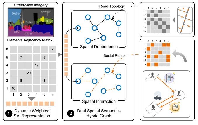
Multi-level urban street representation with street-view imagery and hybrid semantic graph
Yan Zhang, Yong Li, and Fan Zhang
ISPRS Journal of Photogrammetry and Remote Sensing, 2024
@article{zhang2024multi,title={Multi-level urban street representation with street-view imagery and hybrid semantic graph},author={Zhang, Yan and Li, Yong and Zhang, Fan},journal={ISPRS Journal of Photogrammetry and Remote Sensing},volume={218},pages={19--32},year={2024},publisher={Elsevier},doi={10.1016/j.isprsjprs.2024.09.032},}
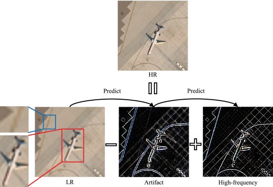
From artifact removal to super-resolution
Jiaming Wang, Zhenfeng Shao, Xiao Huang, Tao Lu, and 2 more authors
IEEE Transactions on Geoscience and Remote Sensing, 2022
@article{wang2022artifact,title={From artifact removal to super-resolution},author={Wang, Jiaming and Shao, Zhenfeng and Huang, Xiao and Lu, Tao and Zhang, Ruiqian and Li, Yong},journal={IEEE Transactions on Geoscience and Remote Sensing},volume={60},pages={1--15},year={2022},publisher={IEEE},doi={10.1109/TGRS.2022.3196709},}